Cross Country Planning
1. Mark the course on the sectional. Consider the airspace, terrain, aircraft performance (ceiling/range). Check airplane weight and balance. Check available runway lengths and aircraft performance.
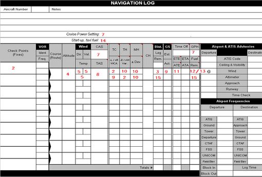
2. Decide on and mark checkpoints. Think about your ability to identify them from the air. Using the plotter measure the True Course (TC). Enter the checkpoints, TC and Variation in the nav log. [Nav Log entry]
3. Using your plotter, measure distances between the checkpoints and enter in the Nav Log.
4. Decide on appropriate cruise altitude and enter in Nav Log
What is the Magnetic Course (MC)?
Remember to subtract Easterly Variation and to add Westerly Variation (“East is Least, West is Best”)
Then for you MC, the VFR cruising altitude is, from FAR 91.159:
0 – 179 –> Odd Thousands plus 500 feet
180 – 359 –> Even Thousands plus 500 feet
5. Check DUATS
a. Enter the following information on your Nav Log:
i. Wind direction and speed (Is the forecast wind true or magnetic?)
ii.Temperature aloft
6. Using your flight computer, calculate the cruise density altitude
7. Go to the Airplane Flight Manual
a. For your planned cruise power setting and density altitude, determine the Calibrated Airspeed (CAS) and fuel burn rate in cruise
b. Enter CAS, fuel burn rate and cruise power setting in Nav Log
8. Using flight computer, calculate cruise true airspeed (TAS) and enter it in the Nav Log
9. Using the flight computer, calculate the Wind Correction Angle (WCA) and groundspeed and enter them in the Nav Log
10. Calculate the following and enter them in the Nav Log:
a. True Heading (TH) = True Course (TC) +/- Wind Correction Angle (WCA)
b. Magnetic Heading (MH) = TH +/- Variation
c. Compass Heading (CH) = MH +/- Deviation
11. Using flight computer calculate and enter in the Nav Log, the Estimated Time Enroute (ETE) for each segment
12. From the Airplane Flight Manual, find the time, speed and fuel burn to climb to altitude and enter in the Nav Log.
13. Calculate the fuel used for each segment and enter in the Nav Log
14. From the Airplane Flight Manual, find the fuel burn for start up and taxi and enter in the Nav Log.
15. Calculate the distance and fuel remaining for each segment and enter in the Nav Log
16. Call FSS: Check TFRs and NOTAMS and file a flight plan.